Inhalt
Historischer Rundweg - Board 9
Alter Markt
As of the 17th century fortifications, gates and a market square gave Weeze a town semblance.
Market
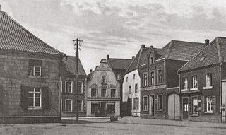
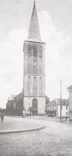
The approximately 50 metre-long market square in front of the parish church of Sankt Cyriakus is first mentioned in 1441 in connection with a house transfer. The market develops into a lively trading place, not least of all due to the fact that the trading route between Cologne and Nijmegen runs for hundreds of years through the town centre.
The annual market was connected to the church consecration day and the „Kirmes“ (annual fair). It was held for four days. Initially, for a long time in October and since 1841, up until today, it is held on the first Sunday in September.
Especially desirable trading goods included wool, Weeze clover seeds and wheat. National interest was also aroused by the fruit, pig, cattle and butter market, and as of 1885 also by the cattle and horse market.
Today there is a weekly market, every Wednesday, on the “Alter Markt”(old market square).
The „Wasserstrasse“ und „Markt“ were seen as noble addresses. Wealthy families and almost all dignitaries lived here in large houses. The town administration was situated here in a mayoral office on the “Markt” (market) between 1938 until 1967.
The market with the local Wasserstrasse and adjoining Schmiedestrasse have ever since built a central point in the Municipality of Weeze. In the 1980’s the area was redesigned, expanded and traffic-calmed. The street paving design with its red plaster stones has since then played an inviting roll in luring guests to the restaurant terraces in the town centre.
Wasserstrasse und Schmiedestrasse
The Wasser-, Schmiede- und Roggenstrasse are the old historical streets of the once fortified town centre of Weeze. A possible reason for the name Wasserstrasse could be that it was often flooded, due to the proximity of the nearby River Niers.
In the 19th century the Schmiedestrasse developed into an economically central point in Weeze. The town hall was located here until 1938. The street skyline was originally dominated by one-storey buildings until about 1900 when two-storey patricians’ houses dominated here. Eventually the last of the farm houses disappeared from the central area of the town. Nearly every house on the street had a shop. From objects of daily use to elegant hats and jewellery almost everything was available here. A four-storey high cigarette factory as well as three blacksmiths all close to one another were established on Schmiedestrasse - in about 1900 there were five blacksmiths in the town centre.
Fortifications
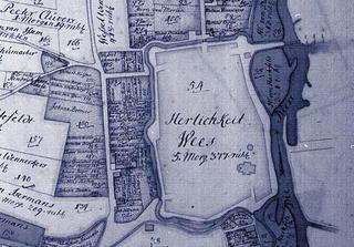
During the 80 year struggle for freedom (1568 – 1648) of the Dutch against the Spanish the Lower Rhine Region, as a passageway, was over and over again used an as an army encampment. As a result, Weeze’s citizens decided in 1593 to build embankments and ditches around their village within a year. The embankment covered an area of approx. 6 hectares and had four gates, which had wooden bridges as a means of traversing the exterior ditches. The citizens were aided by the knowledgeable mercenary Steven Spanier, who also agreed, in the case of war, to organise the military defence of the village.
In spite of the defences the citizens of Weeze were unable to hinder the pillaging of their village in 1639 through the imperial troops of Field Marshall Ottavio Piccolomini and his captain Francesco del Carretto di Grana.
Town-like appearance
The defensive fortifications with gates and the market square in front of the church gave visitors in the 17th and 18th century the impression that they were in a town. However, the town has never been bestowed with town-rights. Since 1649 the town had 9 farming communities (Vorselaer, Steeg, Helsum, Rottum, Hoest, Vornick, Wemb, Baerl/Baal and Siebengewald) which were transferred, complete with land rights, to the owners of Hertefeld Manor, who had held the protectorate rights since 1358.
The population of Weeze around the mid-17th century was about 1,000 and was as big as that of the town of Krefeld.
In the second half of the 17th century the fortifications fell, because of a lack of maintenance, into total disrepair They are, however, clearly visible on maps and sketches from the 18th century.


 02837 9100 (Zentrale)
 info@weeze.de
 Facebook