Inhalt
Historischer Rundweg - Board 1
Historical overview
The Municipality of Weeze is one of the oldest settlements in the Lower Rhine Region. The town can reflect on a diverse history, which can be discovered and pursued in the town centre.
Welcome to Weeze!
We would like to invite you to an interesting tour around one of the oldest settlements in the Lower Rhine Region. Discover more about the idyllic village located in the direct vicinity of The Netherlands on 14 historical information boards around the town centre. The town owes its attractiveness to the delightful countryside, the Niers River and its central location in the County of Cleves, as well as to its accessibility, its ever-changing history, the cosmopolitan nature of its townsfolk and their love for their native town.
The Municipality of Weeze wishes you a pleasant and enjoyable stay.
700 to 450 BC
There is proof of more than one Iron Age settlement in the area covered by the Municipality. In 2005 archaeologists unearthed urn graves on the Cyriakus Square.
7th century
The existence of a settlement with four to six buildings, near the town centre, of the Merowingian-Franconian period is archaeologically documented.
855 A.D.
First documented mention of the "Villa Geizefurt", a Middle Ages building complex with an administrative focal point in the Weeze farm settlement of Kalbeck.
About 1080 A.D.
Documented proof of the land plot 'Wezevelde'. First origin of the name of the town meaning meadows or meadow land.
1226 A.D.
First dated documentation of the town's name: Henry III, ruler of Alpen, gifts the Cistercian Abbey Kamp a building in the farming community of Vornick in the parish of Wise/Weeze.
1326
Summit in the parish church of Sankt Cyriakus. In the presence of numerous knights and some of the local inhabitants the Dukes of Cleves and Geldern agree to the joint exercise of court rights in Weeze.
1461 - 1802
A monastery is founded by the Third Order of Saint Francis near the town centre. It is named Maria ad Aqua/Marien-Water due to the moist grounds upon which it is built. It is de-established in 1802.
1473
After many years of war the Geldrian Administration of Goch, to which Weeze belongs, (it is totally destroyed by a fire in 1466), is taken as war bounty by the Dukedom of Cleves. Weeze is, from this moment on, one of 50 Cleves villages.
1497
Wissen is promoted to a fiefdom.
15th to 18th century
The inhabitants suffer several occupations, pillaging, and fires as well as the occupation of foreign armies.
1593/1594
Strengthening of the village with fortifications and ditches upon order of its leaders.
1609
Upon decree of the Elector of Brandenburg, Steven VII of Hertefeld to Kolk takes up the feudal rights for the Dukedom of Cleves which includes the area of Weeze.
1635 - 1636
Foreign armies of mercenaries spread the plague in Weeze and the local area.
1647
Kalbeck is promoted to the status of a fiefdom.
1649
The lords of Hertefeld buy the fiefdom of Weeze along with nine farm settlements.
1666 and 1769
Heavy fires destroy the town.
1794 - 1814
France occupies and annexes the left Lower Rhine Region. The Municipalities Weeze, Wissen and Kalbeck, which were established in 1798, are joined together in 1800 to farm the Mayoral Town of Weeze.
Since 1863
Weeze is connected to the Cologne - Cleves railway line.
About 1870
Weeze is known as the 'shoe village' of the land county of Geldern. Shoes are delivered as far as Krefeld and Wuppertal. The art of shoe-making fades away as industrialisation grows.
Since 1875
Out of small beginnings a strong carpentry and furniture production develops, which up until today gives the town the nickname 'carpentry town'.
1928
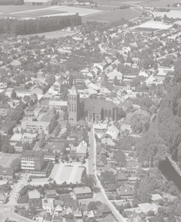
Fusion of the independent Municipalities of Weeze, Wissen and Kalbeck to form the large Municipality of Weeze. It is the biggest land municipality in the County of Geldern.
1945
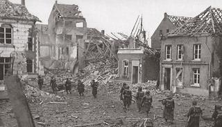
Severe destruction of the town (85 %) and northern farm complexes as a result of heavy fighting between German and Allied troops.
1945 - 1948
On a field near the houses of Wissen approx. 230,000 German soldiers are repatriated to their home towns and are freed from captivity.
1980's
Redevelopment of the town centre.
1954 - 1999
The NATO airbase 'Laarbruch' is built on the heather lands of Hees and serves as a British military airbase for the Royal Air Force. During peak times as many as 5,700 airmen and their families are stationed in the Municipality of Weeze.
Since 2003
Civil usage of the former airbase as Airport Weeze with its ‘Euregional Centre for Air Transport, Logistics and Industry’.
2014
The population of Weeze rises to above 11,000 inhabitants.
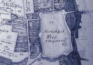
The town centre of Weeze (highlighted) was surrounded by embankments and ditches in the 17th/18th century.
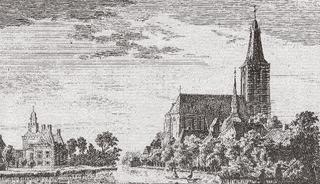
Hertefeld Manor and the Sankt Cyriakus Church as seen from the north. A copperplate etching by P. van Liender from a drawing by Jan de Beijer, 1743.
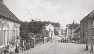
Bahnstraße, a view from the rail crossing, 1906. In the foreground on the left the 'Handelshof' of the Halmanns family and on the right the 'Niederrheinische Molkerei' (dairy).


 02837 9100 (Zentrale)
 info@weeze.de
 Facebook